It is known that overshooting tops in thunderstorms are strongly correlated with severe weather. In addition lightning jumps have been also been associated with large hail, heavy rain and possibly tornadogenisis. By looking at a blend of lightning density and satellite isolating overshooting tops via the 10.3 micron band we may be able to identify the most intense severe thunderstorms on a given day. In the second half of May 2019 Severe thunderstorms affected the central US as well as parts of the Continental US for several days in a row. Below are five separate satelite and lightning loops for May23rd to the 27th and the respective NOAA SPC Severe Weather Reports for those days.
However there are a couple caveats to consider before reading.
However there are a couple caveats to consider before reading.
- Overshooting Tops(OSTs)
- The colored spectrum of the OSTs are derived from the 10.3 micron IR channel and it starts from the measured temperature of the Equilibrium Level(EL). The height or temperature of the EL is highly dependent on the airmass. In addition it isn't the same from one day to the next, however it should depict the OSTs in the area of interest.
- Lightning Density
- The lightning density for these cases only covers the eastern continental US and only as far south as 20 North. However most of the outbreak and severe weather are within this domain.
May 23rd, 2019


May 24th, 2019

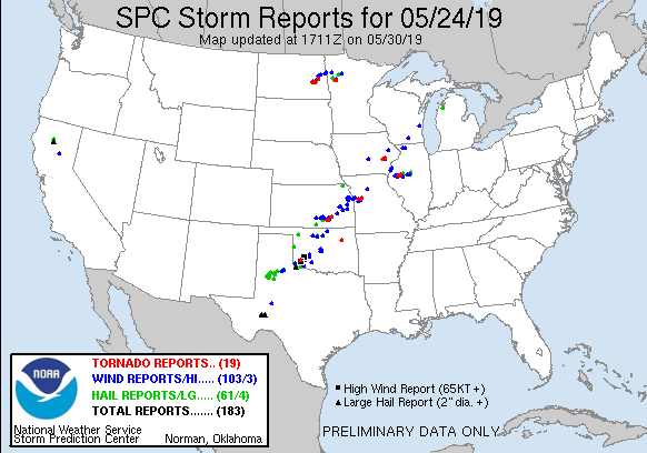
May 25th, 2019


May 26th, 2019


May 27th, 2019


No comments:
Post a Comment